London's All Ages and Abilities Protected Bike Lane Network: Our Vision
I wrote this piece originally in April 2017, and updated a few minor things in January 2019 to reflect new information. Still, very little has changed since the original piece was published, and no all-ages-and-abilities protected bike lanes (cycletracks) have been built in 20 months.
In the middle of last week, after spending some time riding around the city, I started dreaming about what a complete protected bike lane network might look like in London. This is a concept piece, not intended as a final version, that is built from considerable experience riding a bike every day in London, Hamilton, Toronto, Calgary, Edmonton, Vancouver, Montreal, Boston, and Berlin. The installation of this entire network could be completed in a few months, and would cost a very small fraction of what the city is proposing to spend on BRT. Providing safe spaces to get around by bike is the least expensive transportation infrastructure a city can build, and it comes with incredible health benefits for residents of the city. Let's start thinking about what London's AAA bike network would look like.
Here are the design principles that constrained my thinking:
-
Safe. This means protected bike lanes. All bike lanes in the AAA network must have physical separation from fast moving motor vehicles, and physical protection at intersections. Intersection protection, as explained in this video, is essential for safety and comfort of people on bikes. One-way cycletracks should be built on each side of the street, in the regular direction of traffic flow. Two-way lanes should not be used for an on-street network. Painted lanes should only be used on streets designed for speeds less than 40 km/h, of which London has very few. Bike boulevard street conversion may be desirable for some of the routes with lower speeds through residential neighbourhoods, particularly Huron Ave, and Baseline Rd routes. Bike boulevards have some great advantages for residents (less cut-through traffic, slower 30 km/h street speeds in residential areas) and people riding bikes (safe space to ride, support for crossing busy streets).
-
Maintained. Snow clearing in the winter, street sweeping in the summer, built with smooth asphalt surfaces (not sidewalk concrete blocks). The AAA routes must be priority access for doctors who need to see their patients, teachers who have a classroom full of kids, and construction workers on a job site with tight deadlines. Think people won't ride in the winter? Think again. If these two amazing women can go from newbie cyclist to year round commuters, you can too!
-
Connected. People on bikes mostly want to go to the same places that people in cars, or those riding transit, want to go. The network must connect to places with high densities of residents or businesses. Think King Street, not Central. Richmond St., not Colborne.
-
On street. The Thames Valley Parkway is a great place to go for a ride on a Sunday afternoon, but it reaches very few destinations, and is perceived as dangerous at night to many "Interested but Concerned" riders. Brightly lit, well-traveled streets are the best way to design a Triple-A network.
-
Direct. People want to get from A-B quickly. In order to replace car trips, bikes have to be competitive in terms of speed. Bike routes don't need to go everywhere, but you should be able to get most of the way you need to go in a protected bike lane.
-
Use secondary roads when possible. In almost all cases, the volume of traffic on major arteries prevents a pleasant cycling experience. Better route selection for cycletracks makes riding a bike enjoyable, and designing a pleasant ride makes it more likely that people will choose a bike. However, we cannot be afraid to make space on major arteries where necessary, especially when crossing the rivers or train tracks (Adelaide N, Wonderland Rd for example).
-
Downtown use Dundas Street. Dundas is the heart and soul of the city. From the Forks to Western Fair, a rebirth of London's urban form requires a vibrant Dundas Street, including cycletracks. Dundas is the only connected, wide-enough, E-W road that could effectively host cycletracks. No other street comes close in terms of directness, or connectivity to destinations downtown. The new flex street, Dundas Place, will easily accommodate bikes, and bikes mean a boost for business, as Calgary's flex street, Stephen Avenue, has found. Motor vehicles have sufficient access to Dundas businesses from King and Queens, and there is ample car parking on those two streets. Finally, in the long term I envision a Dundas street that belongs to people on foot or bike, "From the Forks to the Fairgrounds."
With those criteria in mind, here's the proposed network:
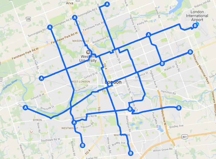
This network is made up of ten numbered Bike Routes (click here to see the whole map with Route numbers, Google won't let me embed a map with labeled numbers, unfortunately). Odd routes run North-South, even routes run East-West. Routes would be signed like bus routes to make it easy for people to navigate. A typical navigation instruction to a visiting tourist could be, "Ride east on Bike Route 2, turn left at Bike Route 5, travel 500 meters and you'll wind up at the Brew Pub." This design provides a way for people to safely navigate most of the city, and reach their destination comfortably on a bike. Google estimates the travel time across the city as 45 minutes N-S (Masonville to White Oaks), and 50 minutes E-W (Byron to Clarke Road). I can't envision a lot of people traveling all the way from Byron to Clarke Road by bike every day, although some dedicated people certainly will. However, I can envision many people using the routes to go partway, or halfway on the routes, which would link virtually everyone in the city to Downtown or many other destinations, in less than half an hour. Half an hour of casual bike riding is a fun way to start every morning, and a great way to feel fit and healthy. Let's design a city that makes it comfortable for ordinary people to reap the health benefits of riding a bike.
Finally, as a bit of an aside, London has 3,680 lane-km of paved roads in the city, 1,465 of which are considered to be primary routes or expressway. The network proposed here represents less than 100 lane-km of protected bike routes. It's entirely sensible to convert 3% of existing roads to protected space for bikes. Every bike that's on the road is a person who's out of their car, which will lessen traffic congestion for everyone. That's a goal I think everyone can agree on.
Comments
Be the first to comment...